British Assam
Ahom palace intrigue and political turmoil due to the Moamoria rebellion aided the Burmeseto invade Assam and install Chandra Kanta Singh as a puppet king in 1817. In 1821, Singh switched his allegiance to the British, leading the Burmese to invade again. The Burmese defeated the Assamese army in 1822, and made Assam a Burmese province under a military governor-general.[17][18] With the Burmese having reached the East India Company’s borders, the First Anglo-Burmese War ensued in 1824. The war ended under the Treaty of Yandabo[19]in 1826, with the Company taking control of Lower Assam and installing Purander Singh as king of Upper Assam in 1833. The arrangement lasted till 1838 and thereafter the British gradually annexed the entire region. Initially Assam was made a part of the Bengal Presidency, then in 1906 it was a part of Eastern Bengal and Assam province, and in 1912 it was reconstituted into a Chief Commissioners' province. In 1913, a Legislative Council and in 1937 the Assam Legislative Assembly was formed in Shillong, the erstwhile capital of the region. The British tea planters imported labour from central India adding to the demographic canvas. After few initial unsuccessful attempts to free Assam during the 1850s, the Assamese since early 20th century joined and actively supported the Indian National Congress against the British.
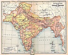
At the turn of the 20th century, British India consisted of eight provinces that were administered either by a Governor or a Lieutenant-Governor. The Assam Province was one amongst those major eight provinces of British India. The following table lists their areas and populations (but does not include those of the dependent Native States):[20]
During the partition of Bengal (1905–1911), a new province, Assam and East Bengal was created as a Lieutenant-Governorship. In 1911,East Bengal was reunited with Bengal, and the new provinces in the east became: Assam, Bengal, Bihar and Orissa.[20]
Table below shows the major original provinces during British India that includes The Assam Province:
| Province of British India[20] | Area (in thousands of square miles) | Population (in millions of inhabitants) | Chief Administrative Officer |
|---|---|---|---|
| Burma | 170 | 9 | Lieutenant-Governor |
| Bengal | 151 | 75 | Lieutenant-Governor |
| Madras | 142 | 38 | Governor-in-Council |
| Bombay | 123 | 19 | Governor-in-Council |
| United Provinces | 107 | 48 | Lieutenant-Governor |
| Central Provinces and Berar | 104 | 13 | Chief Commissioner |
| Punjab | 97 | 20 | Lieutenant-Governor |
| Assam | 49 | 6 | Chief Commissioner |
In 1947, Assam including the present Arunachal Pradesh, Nagaland, Mizoram and Meghalaya became a state of the Union of India (princely states, Manipur and Tripura became Group C provinces) and a district of Assam, Sylhet chose to join Pakistan.
[edit]Post British
Since 1947, with increasing economic problems in the region, separatist groups began forming along ethnic lines, and demands for autonomy and sovereignty grew, resulting into fragmentation of Assam.
Since the mid-20th century, people from present Bangladesh have been migrating to Assam. In 1961, the Government of Assam passed a legislation making use of Assamese languagecompulsory. It had to be withdrawn later under pressure from Bengali speaking people inCachar. In the 1980s the Brahmaputra valley saw a six-year Assam Agitation[21] triggered by the discovery of a sudden rise in registered voters on electoral rolls. It tried to force the government to identify and deport foreigners illegally migrating from neighboring Bangladeshand changing the demographics. The agitation ended after an accord between its leaders and the Union Government, which remained unimplemented, causing simmering discontent.[22]
The post 1970s experienced the growth of armed separatist groups like United Liberation Front of Asom (ULFA)[21] and National Democratic Front of Bodoland (NDFB). In November 1990, the Government of India deployed the Indian army, after which low-intensity military conflicts and political homicides have been continuing for more than a decade. In recent times, ethnicity based militant groups (UPDS, HPDC etc.) have also mushroomed. Regional autonomy has been ensured for Bodos in Bodoland Territorial Council Areas (BTC) and for the Karbis in Karbi Anglong after agitation of the communities due to sluggish rate of development and aspirations for self-government.


No comments:
Post a Comment